The Commonwealth of Massachusetts is immersed in celebration. Planning is well underway for the 400th anniversary of the arrival of the Mayflower in 1620, the 250th Anniversary of the occupation of Boston by the British in 1768 and eventual evacuation in 1776, and the 400th Anniversary of the arrival of the Puritans in 1630. Hingham’s next big celebration–commemorating the landing of Peter Hobart and his group of settlers in 1635–is a way off, with the Town’s 400th anniversary just over the horizon.
 Meanwhile, as we celebrate Massachusetts Archeology Month this October, the Hingham Historical Society is happy to announce that it plans to stretch the frame of celebration in the Commonwealth beyond centuries to eons, or at least to a myrieteris (a period of 10,000 years). An exciting new exhibit, based on archeological discoveries found along the right-of-way during the construction of the MBTA Greenbush rail line in Hingham, will open at the Hingham Heritage Museum in the Fall of 2019. Ancient artifacts representing the earliest recorded life and culture in what we now call Hingham, some dating back 7000 years, will offer visitors a very different understanding of who first lived here, and how they lived. Educational materials will play a prominent role as well.
Thousands of artifacts were uncovered and inventoried by Public Archeological Laboratory (PAL) and UMass/Amherst Archeology during several years of excavation by the Massachusetts Bay Transportation Authority and are now stored in Rhode Island and Amherst. The archeological work was required as a condition of gaining permits to proceed with construction of the commuter rail line.

From “Roads, Rails, and Trails: Transportation-Related Archaeology in Massachusetts,” by Eric S. Johnson, Massachusetts Historical Commission, 2012.
What are the finds? One discovery near Foundry Pond was an anvil stone which provided a surface used to chip and create spearheads and arrowheads for millenia. Found adjacent to the rock in a pile of chips was a Neville projectile point, a type of point known to date to the Middle Archaic period 8000 to 6000 years before the present era (BP).
Native American fire circles and post holes found near the corner of Central and South
Street, remnants of a tannery, including pieces of shoe leather and the sole of a shoe, information about which roads in town were originally native trails, a shiny belt buckle from the 1800s, clay pipe pieces, early redware and colonial pottery pieces–each of these has a story to tell, and all are part of the Town’s rich history.

Archaeologists at work in Hingham Square. Photo courtesy of Public Archaeology Laboratory.
Review and selection of artifacts and story lines are among steps underway in preparation for this new exhibit. Michael Achille of the Hingham Historical Society has formed an Advisory Committee which includes Jim Peters, Executive Director of the Massachusetts Commission on Indian Affairs; Kathryn Ness, Curator of Collections at Plimoth Plantation; Suanna Crowley, President of the Massachusetts Archeological Society; Andrea Young, Administrator of the Hingham Historical Commission; and Andy Hoey and Katie Roberts, representing the Social Studies and Science Departments of the Hingham Public Schools. Historical Society staff and volunteers and representatives of the MBTA, UMass, and PAL will also be key participants in the development of the exhibition and educational program. A generous grant from the Greenbush Historic Preservation Trust is underwriting initial planning and development efforts. The Society will invite individuals and companies to participate in matching this grant.
So keep an eye on this space. Formal announcements and details will appear over the next several months.
 The birds’-eye view of Hingham Harbor, circa 1680, envisions Hingham as its earliest settlers found it, a heavily forested coastal village with a safe harbor and large tidal inlet called “Mill Pond.” The mural’s design concept, developed with
  The focus is on early North Street, later the route by which woodenware from village workshops of Hingham Centre and Hersey Street made their way down the harbor where ships awaited to carry them worldwide. The twilight setting was inspired by exhibit writer Carrie Brown’s description of candlelit homes in a world fueled and maintained by wood.
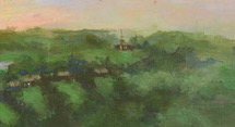 suggested the steeple of Old Ship Church (not yet built) to help locate the site of an earlier meetinghouse on Main Street. At the harbor a single wharf, likely located at the mouth of Mill Pond, suggests the beginning of Hingham’s commercial harbor. In later years, Hingham harbor’s many wharves were key to the success transporting goods produced by local tradesmen to Boston and beyond.
 The viewer may be surprised at the prominence of Mill Pond—how it extends in the distance to what is now Home Meadows. This once broad expanse of water carried early settler Peter Hobart and company to their landing point at the foot of Ship Street at North Street. Mill Pond, flushed by tidal waters and fed by the Town Brook, is, alas, no longer. In the late 1940s it was “paved over for a parking lot” along Station Street and the historic brook sent underground. The vestige of Mill Pond’s shoreline still remains, along the rear of old buildings lining the south side of North Street.
 Research was important to surmise how Hingham Harbor may have first appeared to arriving settlers. I found no local 17th century drawings or paintings on which to base the design. Instead I used a variety of sources to help me understand what might be a plausible view. My research included: