Hingham’s Unbuilt Highways, Part 2

As discussed in our prior post, Hingham’s Unbuilt Highways, Part 1, traffic has been an issue for the Town of Hingham for nearly 100 years.  This has been particularly true for Main Street.  Each time the State proposed a plan to solve the problem, though, concerned citizens have stepped forward to oppose what they saw as a threat to the town’s character.

When Route 128 was extended into Hingham (heading to Nantasket Beach) in the late 1920s,  increased complaints about traffic on Main and East Streets led the State, by the mid-1930’s, to promise a bypass route for traffic relief.  The route that it proposed followed Gardner Street, starting at Whiting Street, crossing Main Street, and eventually turning north through the less developed eastern part of town into Hull. Funding issues stalled any actual construction, however. In 1938, the State offered a “temporary fix,” offering to build a rotary in Hingham Centre at the intersection of Main, Short, and Middle Streets.

The Hinghamite, August 1941

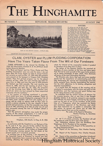
August 1941 issue of The Hinghamite, a monthly newspaper published by Albert L. Pitcher during the 1940s

As reported in August 1941 issue of The Hinghamite, the rotary plan, which probably would have resulted in several historic buildings being torn down, was halted by the efforts of Mrs. David T. Whiton and Miss Ethel H. Studley, owners of some of potentially effected properties.  They gathered a petition of nearly 250 names and packed a public hearing which convinced the State to back down. The Town did agree to better signage, more traffic islands, and other measures to help ease traffic problems.

View of Hingham Centre from corner of Main and Short Streets, 9/8/13

Hingham Centre, as seen from the corner of Main and Short Streets in September 2013. Some of these buildings might have been torn down if the State’s rotary proposal had gone forward. Photo by Robert H. Malme

By the 1950’s and the dawn of America’s freeway age, renewed efforts were made to take traffic off Main Street, this time with a proposed relocated Route 128 expressway. Highway surveyors were for time a constant presence in several parts of town.  Leavitt Street resident Carl Burr (whose diary we have blogged about previously) mentioned being visited due to his property being in the potential path of the new highway. By the time the State got serious about the project in the late 1960s, the southern end of Route 128 had been pushed back to Braintree, and the route running through Hingham to Hull was renumbered Rote 228. On February 29, 1968 the State held a public hearing at Hingham High School to describe its proposal for a relocated Route 228:

Proposed Relocation of Route 228 in Hingham-Norwell-Hull

The State’s proposal was an 8-mile, four-lane expressway (250 to 400 feet wide) from Route 3 to George Washington Blvd. in Hull.  According to the State, this would fulfill three specific goals: to stimulate residential development and recreational activities for the towns along its route, to provide traffic relief to local streets, and to provide safety, comfort and reduced travel times to motorists. The State offered three alternatives for this proposed expressway’s route through the southern and middle parts of Hingham.

Proposed Relocation of Route 228 in Hingham, Norwell and Hull

The “Gardner Line” alternative began at an interchange with Route 3 in vicinity of today’s Derby Street Shoppes, taking the route across Whiting Street and south of Gardner Street, across Main Street then turning north in the vicinity of Prospect Street. The two other alternatives, the “Pond Line” and the “Webster Line” started at Route 3 in Norwell and ran north to Prospect Street.  From Prospect Street, all three proposed routes proceeded north along a “Common Line” running parallel to the border of today’s Wompatuck State Park.  North of Free Street (where an interchange was planned), three alternative routes were again proposed north to Hull.  Two of these proposed routes, the “Western” and “West Central” Lines would have required “relocating” Triphammer Pond and the Weir River.  The “Eastern Line” would have run east of Triphammer Pond but would have skirted Turkey Hill.

All three proposed routes intersected with Route 3A (with a large interchange) at between Summer Street and today’s Weir River Farm. Any of the alternatives would have condemned 17 to 26 houses and requiring those living in them to move and would have cost $12 to $15 million (in 1968 dollars).

View from Top of Turkey Hill

View from top of Turkey Hill–which would have been much different if the Route 228 expressway had been built.  Photo by Robert H. Malme, May 2015

Many Town officials were receptive to the plan, provided that the State chose one of the Norwell routes. The Selectmen even asked the State to add an interchange at Rockland Street in the event the Eastern Line was chosen. In the spring of 1968, however, Norwell rejected the proposed routes within its borders due to their proximity to the municipal water supply, and the State indicated that the Gardner Line would probably be its recommended southern alternative.

At a Special Town Meeting held on September 30, 1968, Hingham voters rejected the State’s plans by a narrow vote of 559-506.  (A second article, requiring the Selectmen to insist upon the Pond-Common-Eastern Line configuration if the State moved forward with a highway despite the Town’s vote, passed 422-231). Since neither Norwell nor Hingham would approve a southern route through their respective towns, no construction was started. By the early 1970s, with continued opposition and with overall sentiment for expressway-building waning in the metro Boston area waning (a trend exemplified by the cancellation of the Southwest Expressway in Boston), the State abandoned the plan.

Continued traffic problems on Main Street, however, revived the idea of building a relocated Route 228 in the early 1990s. Several frustrated Main Streets resident asked Selectmen to reconsider the State’s 1960s plan. This time, however, a large majority of town citizens and the town’s officials stood up against this idea. Their sentiments were best summed up in a letter which John P. Richardson wrote to the editor of the Hingham Mariner on August 8, 1993, arguing that any such highway would ruin one of the town’s gems, Wompatuck State Park.

richardsonletter8893

Letter to the Editor of the Hingham Mariner, written by John P Richardson on August 8, 1993.

The idea died quietly and has not been revived. Current sentiment with building new roads to solve traffic problems can best be summed up by the response of the Town Traffic Committee to the complaint of a frustrated Main Street resident, as reported in the July 29, 1993 Hingham Mariner.  When the Main Streeter asked what could be done for relief from the traffic noise, the response was, “Move to Plymouth.”

Hingham’s Unbuilt Highways, Part 1

For nearly the last 100 years, residents of Hingham have had to deal with traffic congestion in its downtown, the harbor area, and along Main Street. The recent effort by the town to survey residents about possible improvements to Route 3A and Summer Street is only the latest attempt to try to solve the town’s traffic problems. Documents from the John Richardson Collection and other materials in our archives confirm that the search for a solution to traffic problems has a long history.

Starting in the 1920’s the town asked the state to fund a project to take beach and through traffic away from Hingham Square. The state took the easiest solution and expanded Broad Cove Road and Otis Street to four lanes so that 3A could be re-routed away from the eastern end of Lincoln Street and North Street in 1932. Though successful, this action reduced the ability for non-automobile traffic to easily access the waterfront from that date forward. Around the same time, to further speed Nantasket and other traffic east of the Harbor, the state also built Chief Justice Cushing Highway, with the now infamous Harbor Rotary, and constructed George Washington Blvd. to Hull.

Looking North towards the Harbor Rotary in 1941:

Hingham Rotary and Harbor (1941)With the 1950s came the start of the freeway era in the country and Massachusetts. By 1959, the state had completed the 128 Beltway, the Central Artery, and the Southeast Expressway as far as Derby Street (later to be Route 3). Hingham officials saw the new expressway as an opportunity to attract tax-producing industrial and commercial development to South Hingham but also worried about what a potential residential population boom would do to the town. With these thoughts in mind, the Hingham Planning Board produced a report called the ‘1959 Town Plan Summary’ which projected Hingham’s population as 25,000 by 1980 and made a series of recommendations to best accommodate this growth while preserving the town’s character.

Cover of 1959 Planning Board Report:

1959 Hingham Town Plan Summary

The report made two recommendations to help increase recreational use of the Harbor. The first was to fill parts of it to connect the Harbor islands to the mainland and build a marina where the Yacht Club is now, as seen in the map below.

Hingham Harbor Plan (1959)

Second to ease waterfront access to town citizens, and to help solve many of the town’s traffic problems, the Board recommended building a pair of parkways (which, depending on costs, would be built as limited access expressways right away, or upgraded to them in the future) to take Nantasket and other through traffic away from the Harbor area and from Main Street (see Location A in the map below). The north-south parkway would take through traffic from Route 3A at the Back River Bridge southward parallel to Beal Street (by the Ammunition Depot, slated to close and holding out the opportunity for industrial development) and then further south along the western side of town to Route 3. The east-west parkway would then take southbound and Nantasket traffic east, following a route through the center of Town, north of High and Free Streets, and then across 3A to George Washington Blvd.

1959 Hingham Highway Plan

Neither of these plans got off the drawing board: they appear to have largely been an alternative to the state’s known plans for the Hingham area, which included, as can be seen referenced on the top left side map, the Shawmut Trail. The Shawmut Trail was a proposed expressway that would have run from Route 3 near today’s Braintree Split eastward across the Fore River (over a new bridge) to Route 3A in Weymouth just west of the Back River Bridge. It would then have continued into Hingham mostly along the path of Route 3A to end at the proposed Route 128 (later 228) Expressway near Turkey Hill (shown on Map C). As can be seen on the Location B and C Maps above, a portion of the Shawmut Trail route would have run directly from the Broad Cove Rd/Otis Street intersection to the Rotary. This would, as the report notes, involve running Route 3A “on a dike across the southern shallows of the Harbor cutting off the ponded areas from further recreational or boating use.” In other words, this plan would have prevented most of the current activities in the southern end of the harbor.

View of the southern end of Hingham Harbor from the Bathing Beach in 2014, a scene that would not be possible if the Shawmut Trail had been built:

View of the southern end of Hingham Harbor from Bathing Beach, 8/9/14
Photo by Robert H. Malme, 8/9/14

Needless to say, this plan did not impress Hingham’s citizens or town officials. By the end of 1968 the state relented and ended the proposed Shawmut Trail in Weymouth. In the early 1970s the state officially abandoned the plan. Though none of these proposal came to be, a plan to build a relocated 228 expressway came much closer to fruition. More about that in Part 2.


One Family’s Tradition of Service, Part 2

Captain Gorfinkle returned to America after his service with the Peace Delegation was complete and continued his military service as part of the reserves. Promoted to Lieutenant Colonel, he organized many philanthropic campaigns to aid military service people in the Boston area between World Wars. One charitable effort involved the donation of pianos to military bases throughout New England and beyond, including the Hingham Naval Ammunition Depot.

blghadnote

Colonel Gorfinkle continued his patriotic service in World War II, serving as a member of the War Manpower Commission, appointed by President Roosevelt to oversee the New England region. After the war, he remained active in the Reserves, serving as military attaché for Massachusetts governors Christian Herter (1953-1957) and John Volpe (1962-1965). He finally retired from Reserve service in December 1965—at the age of 71. Besides his law practice and military service, he was an active philanthropist in the Boston area, and chief among his interests were Beth Israel Hospital, the Newton Tennis & Squash Club, which he helped found, and Brandeis University.

The Colonel’s son, Herbert J. Gorfinkle, continued the family tradition of military service and was also involved in this country’s efforts during World War II. He was a member of the 381st Engineers Combat Battalion, which deployed to Europe following D-Day, serving as Unit photographer. His unit stayed in Germany for a year after the war helping rebuild that country’s infrastructure. His collection contains many photos of bridges over the Rhine River which his unit was helping rebuild. It also includes letters home to friends and family.
hjgrhine1

After the war, Herbert Gorfinkle completed his education at the University of New Hampshire in 1947 and then received a Master’s in Business Administration from New York University’s School of Retailing in 1948. He then started a successful career in the mercantile industry, serving as manager or founder for several successful retail chains including Jordan Marsh and the Edwards Stores of Boston. He and his wife, Connie, moved to Hingham from Braintree in 1972 and raised three daughters on Andrews Isle within the Home Meadows—near Hingham Harbor, which he helped champion as member (1983-1990) and Chairman (1988-1990) of the Harbor Development Committee. Herbert Gorfinkle was also a member of the Veterans of Foreign Wars Coast Guard Auxiliary and Commodore of the Metropolitan Yacht Club.
Hingham_Harbor_Proposed_500

One Family’s Tradition of Military Service

John Richardson of Hingham made the preservation of Hingham’s history his life’s work, amassing a large collection of Hingham-related books, furniture, artifacts, documents, and “ephemera.” He once wrote that he had “over 75,000 documents, diaries, journals, letters, surveys, maps, tax lists, photographs, etc.” in his collection, and the Hingham Historical Society was lucky enough to receive part of this treasure trove upon his death in 2011.  Three years later, we continue to work at cataloguing his substantial donations to our archives.

While most of the Richardson material chronicles the history of Hingham and lives of its citizens, some takes you into the lives of individuals outside of town and to places outside the country. One of these people was Colonel Bernard L. Gorfinkle (1889-1974) of Boston, whose father‘s family immigrated to the North End of Boston in the late 1800’s, when that neighborhood had a substantial Jewish population. Among the Richardson materials on which we are working are six three-ring binders and one box comprising the papers of Colonel Gorfinkle, as well as some of his son, Herbert J. Gorfinkle (1923-2000). The latter provided the Hingham connection, moving to town in 1972 and later giving these family papers to John Richardson.

A page from Bernard Gorfinkle's scrapbook of photographs taken during his participation in the 1916 pursuit of Pancho Villa

Scrapbook photos taken during the 1916 expedition after Pancho Villa

Colonel Gorfinkle was a lawyer. He graduated from Boston University Law School in 1911 but soon found himself heavily involved with this country’s military history. First, his Massachusetts Cavalry unit was called up to help Gen. John Pershing hunt down Pancho Villa along the Mexico border in 1916. His papers include his letters home, photographs, and postcards from his train trips to and from Texas and provide an interesting glimpse of our country prior to World War I.

Captain Gorfinkle won a Purple Heart as part of the American Expeditionary Forces in France, 1917-1918

A decorated member of the American Expeditionary Forces in France, 1917-1918

Colonel Gorfinkle’s military adventures continued when he was again called up in 1917 to serve with the American Expeditionary Force in France after the United States entered World War I. Serving first as a lieutenant staff-member and then as Judge Advocate for the 106th Division, he was eventually promoted to Captain. He made many trips to the front, which he documented in letters and photos sent home, to participate in proceedings against both prisoners of war and American soldiers. His many letters, photos and postcards to family members recount both the exciting and the mundane aspects of life during war time. He spent the last months of the war in 1918 near the front in Verdun where he was wounded. For his service he received a Purple Heart, the American Service Award, plus five other military honors including those bestowed by France and Belgium.

Captain Gorfnkle posing with the American Peace Delegation in Paris after World War I

Posing with the United States Peace Delegation in Paris

After the war, Captain Gorfinkle remained in France as part of the American Peace Commission delegation led by President Woodrow Wilson. He can be seen in the back row, under the arrow, of this photo of the United States delegation.

Postcard of La Madeleine, Paris, sent home by Bernard Gorfinkle

A postcard home from La Madeleine, Paris

The portion of the collection from Colonel Gorfinkle’s time spent in Paris contains copies of transcripts of the meetings at the conference regarding the final settlement with Germany. On a lighter side, he also saved many postcards of the French capital and the surrounding cities he visited.

[Captain Gorfinkle’s experiences–and those of his son–as memorialized in this collection will be continued in our next post.]