 The birds’-eye view of Hingham Harbor, circa 1680, envisions Hingham as its earliest settlers found it, a heavily forested coastal village with a safe harbor and large tidal inlet called “Mill Pond.” The mural’s design concept, developed with Suzanne Buchanan, was to give context regarding the importance of the harbor for trade, the vast resource of timber that later helped drive the woodenware industry, and to depict how the early development of the village stemmed from the harbor front.
Working with exhibit designers Ed Malouf and Carol Lieb of Content Design Collaborative through a series of rough idea sketches, the following design evolved:  The focus is on early North Street, later the route by which woodenware from village workshops of Hingham Centre and Hersey Street made their way down the harbor where ships awaited to carry them worldwide. The twilight setting was inspired by exhibit writer Carrie Brown’s description of candlelit homes in a world fueled and maintained by wood.
We see the village at twilight–simple homes, windows aglow—along “Town Road,” now North Street, where the first settlers were granted lots along an Indian path that followed Town Brook to what is now Beal Street. In the distance, I faintly 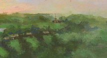 suggested the steeple of Old Ship Church (not yet built) to help locate the site of an earlier meetinghouse on Main Street. At the harbor a single wharf, likely located at the mouth of Mill Pond, suggests the beginning of Hingham’s commercial harbor. In later years, Hingham harbor’s many wharves were key to the success transporting goods produced by local tradesmen to Boston and beyond.
 The viewer may be surprised at the prominence of Mill Pond—how it extends in the distance to what is now Home Meadows. This once broad expanse of water carried early settler Peter Hobart and company to their landing point at the foot of Ship Street at North Street. Mill Pond, flushed by tidal waters and fed by the Town Brook, is, alas, no longer. In the late 1940s it was “paved over for a parking lot” along Station Street and the historic brook sent underground. The vestige of Mill Pond’s shoreline still remains, along the rear of old buildings lining the south side of North Street.
 Research was important to surmise how Hingham Harbor may have first appeared to arriving settlers. I found no local 17th century drawings or paintings on which to base the design. Instead I used a variety of sources to help me understand what might be a plausible view. My research included:
- Maps and harbor views of New Amsterdam and Boston and research done by the committee working on the development of Hingham Harbor’s Master Plan.
- The 1893 History of Hingham, which provided information about the abundant hardwoods early settlers would have seen along the coast and drumlins of Hingham;
- Not All is Changed, Russ and Lorena Hart’s aptly-titled history of Hingham, which includes early maps, including the first 12 lots granted along North Street, and vintage harborfront maps, which helped approximate the location of the first commercial wharf and buildings. These likely extended along Mill Pond near the grist mill, whose ancient foundation supports the old timbers of what is today called Liberty Grille.

[…] “Boxes, Buckets, and Toys” exhibit at the Hingham Heritage Museum has celebrated the craftsmanship of Hingham’s coopers […]