Launching the Hingham Heritage Google Map

I had no idea when I retired in March 2015 that so much of my early retirement would involve projects tied to history.  These projects culminated in the Hingham Historical Society‘s Custom Google Map Project, which I have shepherded for the past year.   As the opening of the Visitor Center at the Historical Society’s newly renovated Old Derby Academy approaches, it is exciting to unveil our work.  The new Hingham Heritage Map is a custom Google map with a series of topical overlays on which locations of local historical significance are geo-located and described.

Not sure what that means?  Just click in the upper left hand corner to see the “legend,” or list of overlays, and in the upper right hand corner to enlarge the map:

Select one of the themed layers using the map “legend” on the left, and the Google map will populate with icons representing sites of interest.  Click on one and scroll down to read more about its history and in some cases, see historic and contemporary photos.  Note: Many historic structures on this map are private homes today, but exteriors can be viewed as you walk, bike, or drive along.

Eileen McIntyre with veterans

Eileen McIntyre with veterans Norm Grossman and Syd Rosenburg (Barry Chin photo for Boston Globe)

Over the past two years, I was pleased to make connections with fellow history-minded Hinghamites whose help and encouragement made the project possible.  In late 2015, I met with Andy Hoey, Director of Social Studies in the Hingham Public Schools, to explore ways I could put my experience with a new StoryCorps smartphone app to use, capturing oral histories. I’d originally thought I might work with some students to encourage their use of the app.  Andy suggested that I consider capturing stories of local military veterans and introduced me to Keith Jermyn, Hingham’s Director of Veterans’ Services. I kept in touch with Andy as I interviewed veterans in town over the succeeding months to come. The initiative was covered in a Globe South story that ran with their Veterans Day coverage last year.  While we did not realize it when we connected about StoryCorps, both Andy and Keith would later prove helpful in the map project.

Detail from W.A. Dwiggins map, “The Old Place Names,” 1935

In March of 2016, I met with Suzanne Buchanan, then Executive Director at the Hingham Historical Society, and others to explore a potential way-finding project for the planned opening of the Visitor Center at the Hingham Heritage Museum.  Over the next several weeks, I researched an earlier signage project explored by the Hingham Downtown Association. My findings suggested that adding more signs to point visitors to Historic Downtown Hingham, and the new Museum, would be challenging. I also realized that for most of us these days, physical way-finding signs are not a major navigation tool. As I pondered this, an unrelated event sparked an idea.

In the spring of 2016 I attended my 45th college reunion and was impressed by a custom Google map the Boston College alumni office had created to guide attendees to the events held on two campuses. I wondered if we could design such a map as an easy-to-access resource to the Hingham history all around us–so I contacted the BC alumni office to find out how the map had been created.  The Associate Director, Strategic Marketing and Writing, of the Office of University Advancement, Stacy Chansky, was very helpful, sending me online resources. Wow, I thought. Maybe some local students could be enlisted to help me with create a custom Google map to showcase Hingham history that would launch when the new Hingham Heritage Museum opened.

I shared my idea with Suzanne and, based on her enthusiasm for the concept, I reached out to Andy Hoey to see if any Hingham High School students could be enlisted when school resumed the following September.  Andy came through for me, not only identifying two interested seniors, but also gaining approval for them to receive course credit for the hours they spent on the project.  Seniors Eliza Cohen and Collin Bonnell and I agreed on a multi-themed approach to mapping the history of our Town. Our objective would be not only to pinpoint locations but also to include text and photographs.

PC158 First Universalist Church

First Universalist Church and Society, now a private home on North Street.

Both students had themes they wanted to research. Eliza set off to document the Town’s historic meeting houses, places of worship, and cemeteries, while Collin dove into Hingham’s rich military history across the centuries. (I contacted Keith Jermyn about Collin’s work and he contributed by giving Collin material on the many military monuments around town.) Later, Collin also would help me research Hingham’s farming history.

Abolition Banner

Banner from Hingham’s historic 1844 abolitionist event at Tranquility Grove (Burns Memorial Park today). 

Other topics I took on were bucket-making and other early industry in town and the history of Tuttleville, a 19th-century freed black community in Hingham.  This latter topic would later expand to include Hingham’s historic relationship to our nation’s abolition movement. Each research topic would become a layer of the custom Google map.  And I made sure that the Hingham Heritage Museum would be represented on each map layer, through a reference to archival materials or artifacts related to the theme for that layer of the map. (I’ve learned much along the way about the rich resource our new museum will be for all kinds of research.)

As the project got underway last fall, the Society’s registrar, Michael Achille, helped us find information and photographs from the Society’s archives and the Public Library’s history collections.  Michael has been invaluable as both an expert resource and a cheerleader throughout this project.  He is now working with Andy Hoey on an Historical Society-sponsored internship for Hingham High School students starting next fall.  Assignments for the students are expected to include future enhancements to the custom Google map we have created for the Heritage Museum.

For a project with the scope of ours, it was best to begin by populating a shared database. We made Google sheets the home for all of the data we began collecting beginning last September.  Later in the fall, one of my contacts from the StoryCorps project, Hingham-based journalist Johanna Seltz Seelen, put me in touch with Yael Bessoud, a university-level history student with good technology skills–and her future son-in-law.  Yael joined our team early this year, first researching photographs at the library and in the Society archives and then referencing the Hingham Comprehensive Community Inventory of Historic, Architectural and Archeological Assets to populate the database with content for additional Google map layers, including ones documenting the more than one hundred pre-1800 homes and other structures still standing in Hingham.  Later, Yael was instrumental in transferring the information we had put into our database onto a Google map.

Everyone involved in this project is excited that, less than a year from the project’s inception, we are launching what is now an eight-layer custom Google map documenting so many aspects of the Town’s history.  I want to give special shout-outs to Eliza Cohen, who is beginning her college studies at the Shanghai, China, campus of New York University; Collin Bonnell, who is off to college at Fordham University in New York City, and Yael Bessoud, who, with an Associate Degree in History from Quincy College completed, is now continuing his studies toward a B.A. in Education at Framingham State University.

The map project is ongoing. I appreciate the recent assistance of Geri Duff, who found digital images for many of the historic homes on the Google map and house histories compiled by Historical society volunteers over many years of Hingham Historical House Tours.  With these, I have been able to enrich the descriptions for many sites.

Other resources of value to the project have included: the entries on this blog, which document many of the archival resources that we have tied into map descriptions; Martha Reardon Bewick’s well-researched Lincoln Day address this year, which filled in much detail about the abolitionist gathering at Hingham’s Tranquility Grove (a site on one of the map layers); photos and stories provided by Town Historian Alexander Macmillan; and valuable clues about Hingham’s extensive dairy farm history provided by Peter Hersey, based on the labels from his historic milk bottle collection.

Any project worth doing “takes a village” . . . or in this case, a Town.

E. Wilder and Son Grocery Store

ph803-large (2)We don’t have many interior views this nice of the old Hingham shops. On the shelves of E. Wilder and Son Grocery Store (at 613 Main St., now the Cracker Barrel) you can see Quaker Oats, Van Houten’s Cocoa, canned foodstuffs, and various tobacco products. The man is Fred Wilder.  Fred worked not only in the store, with his father Ezra, but also in a Weymouth shoe factory, where had had the enviable job of “stitcher.” Fred and his wife, Hattie Shute Wilder, lived in an apartment over the store for 12 years before moving to 606 Main Street.  Fred and Hattie both worked in shoe factories in addition to caring for aging relatives and and the store.

Genevieve Crosby, Shutterbug

Men took the majority of the early photographs of Hingham. As cameras became smaller and film could be sent out to be developed, women took up the hobby as well.  Miss Genevieve Crosby worked as a clerk in the town accountant’s office and loved taking photographs. She picked the hobby up from her parents, Alanson and Charlotte Crosby, who took many photographs of her as she was growing up.

ph730

Genevieve Crosby prepares a shot.  Gift of Genevieve Crosby. In the photographic collection of the Hingham Historical Society

Shown here on Hingham’s North Street before it was paved, Genevieve Crosby prepares a shot–and you can see the delight on her face. Crosby took a series of photos of the interior and exterior of her home at 197 North Street and of Hingham Town Hall and the surrounding areas of town. Together with snapshots of family and friends, they are now in the photograph collection of the Hingham Historical Society, providing a small window into life in Hingham in the 1920s.

ph735

Photograph of Genevieve Crosby as a small child.  Gift of Genevieve Crosby. In the photographic collection of the Hingham Historical Society.

ph235

The parlor hearth of the Crosby home at 197 North Street, Hingham.  Gift of Genevieve Crosby.  In the photographic collection of the Hingham Historical Society

“Gentleman Farmers” of the 19th Century

Brewer BarnThe “gentleman farmers” of the 19th century were men who typically had made their fortunes in that century’s industrial and commercial expansion and, only afterwards and as an avocation, applied the scientific and economic values and principles that had fueled their successes in those arenas to agricultural pursuits.  For instance, in 1856, wealthy Boston businessman John Brewer built a mansion along Martin’s Lane in Hingham, which later grew to encompass the twin drumlins of World’s End and the Hingham Harbor islands, and his son, Francis W. Brewer, built “Great Hill,” an estate off Hobart Street, now More-Brewer Park. (Shown here: a print from a glass plate negative of the barn at Great Hill, the foundations of which can still be seen in the park.)

Portrait of Samuel Downer

One prominent father-son duo of “gentleman farmers” with a strong connection to Hingham were both named Samuel Downer. The father, Samuel Downer, Sr. (1773-1854), was a Dorchester merchant with ties to shipping and the Massachusetts maritime economy.  He was a founder of the Massachusetts Horticultural Society and devoted horticultural experimentalist, known for having developed several new varieties of pears.  We have in our collection a portrait of the elder Mr. Downer, painted by Henry Cheever Pratt in 1840.  Mr. Downer chose to pose with fruit and flowers and a popular naturalistic work of the era called The Romance of Nature—all reflecting his desire to be remembered for his agricultural interests and not the trade and commerce that had led to his wealth and position.

Portrait of Samuel Downer, Jr.His son, Samuel Downer, Jr. (1807-1881), was a pioneer in the development of kerosene and a participant in early petroleum exploration in Pennsylvania.  (Locally, he is known for having bought up most of Crow Point in Hingham and developed the mid-19th century resort Melville Garden.)  This Samuel Downer (photo at right) also cultivated fruit for a hobby.  One of his inventions was “Downer’s Late Cherry,” a useful application of scientific principles to farming: it bore fruit later than other varieties of cherry, effectively extending the local cherry season.

PH503The Hingham Agricultural and Horticultural Society, founded in 1869, was also comprised of local men and women, many of whom were involved in industry, trade, and commerce.  (Here, they pose for a formal portrait in front of Hingham’s Agricultural Hall in the late 1880s or early 1890s.) As a society, they were earnestly dedicated to scientific farming, that is, using the progressive values of the 19th century and the power of new knowledge and industrial technology to “improve” agriculture along “modern” lines. At the agricultural fair each fall, prizes offered in different categories attracted many entrants. One could win a medal or ribbon—and an accompanying cash prize–for anything from crops and livestock to flowers and preserves.

The prizes offered for “Agricultural Experiments” demonstrate this interest in scientific farming.  A poster advertising the 1863 Agricultural Fair (detail reproduced below) offered prizes for the “best conducted experiment” in several areas, including for instance, “ascertaining the most economical manner of apply Manures for a crop of Indian corn, not less than ½ acre . . . .”

Africultural Fair Poster 1863 #2

Hingham Baseball: Reminding Young and Old That We Are All The Same

“Take me out to the ballgame” wrote Jack Norworth in his 1908 song of the same name. By that date, early in the 20th century, baseball had long been considered America’s pastime.

One reason for baseball’s popularity is its unique ability to unite generations.  It is a game that is inherently able to be played by people of all ages and as such has always been a unifying force within small American communities.

Whether it’s a sandlot game between neighborhood kids or a semi-formal league between towns, the game of baseball brings people young and old together under a common love of sport and competition. This was true in Hingham, where informal baseball teams formed as early as the 1870s.

More often than not, these teams were comprised of a mix of men, from schoolboys to middle-aged business owners to retirees, all of whom share in common their love of the game and their sense of community.

Preserved in the archives of the Hingham Historical Society are a number of photographs from this early era of America’s favorite sport. Team photos of Hingham men with their dapper uniforms and basic gear show us not only how frightening it must have been to be a catcher in those days but also how Hingham’s older and newer generations put aside whatever differences they may have had to come together and compete.

reed

This picture, taken c. 1905, illustrates the demographic mix, with a teenager like Charlie Jeffries (back row, far right) playing on the same team as middle-aged William Blake (middle row, far right) and an elderly William Turner (back row, second from left). These men all pose with the same uniform proudly displaying the large Hingham “H.”

reed

Other photos, like this one, depict a team comprised entirely of young men and boys, many of whom would go on to accomplish great things in our town.  This photograph, by amateur Hingham photographer Frank W. Reed includes himself as a player (back row, third from right) along with the bearers of many prominent Hingham names: Ripley, Howard, Lane and Stoddard, to name a few. One player, Wilbur T. Litchfield (back row, second from right) would go on to become one of Hingham’s very first electricians and would help to electrify Hingham’s streets and some of its first homes between 1896 and 1900. (Note the rudimentary catcher’s mask displayed at lower left. The “C” on the players’ uniforms may refer to Hingham Centre.)

As these young men grew, one thing typically stayed the same and that was a love for the game.  We can look at these images and quite literally watch some of these Hingham men age over time through their continued participation in the sport. James H. Kimball was a lifelong fan of the game, appearing in team photos as a young man here in Hingham, going on to play at Dartmouth and later returning to town to continue playing on several teams during his time working for his family’s lumber business on Summer Street.  About the photo below, Jim Kimball wrote

This shows the first Hingham ball team that I played on, in August, 1899.  I was a sophomore at Darmouth.  No larger crowd ever gathered than on that Saturday afternoon in August, when we played the first game against the team which was organized by the Rev. C.H. Porter.  It was a gala occasion and drew a big crowd.

201411713

The photo below is of “Porter’s Players,” the Hingham team’s rival in the epic game Mr. Kimball remembered years later. (The Rev. C.H. Porter was pastor of the New North Church.)  They lost the August game, 8-4, and went on to lose a Labor Day rematch that same year, 9.6.

201411714

Teams started out in plain clothes, with no gear, playing “stick ball” before formally adopting the recognizable equipment and uniform style we see today. The one constant from those early days until now has been the sport’s unique ability to bridge the age gap. Today we recreate that camaraderie through our annual Vintage Base Ball game. Though when you look at these early photographs and watch our “modern” vintage game, one thing becomes abundantly clear: we are all the same. In this way, baseball provides us with a special way to visualize our same place in the community and realize that it just a continuation of generations long past.

Vintage

Isaac Sprague and American Botany

isaac sprague poster '16-100dpi
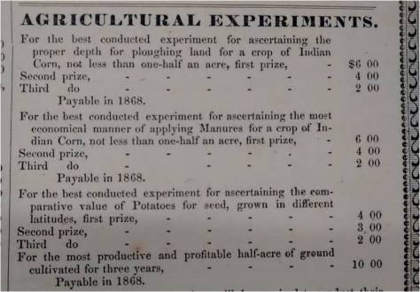
A new exhibit opened today at our 1688 Old Ordinary house museum, 21 Lincoln Street, Hingham. Isaac Sprague and American Botany: Art, Science, and Agriculture in the 19th Century examines the life and work of America’s best-known botanical illustrator–and son of Hingham–and places his art in the context of several currents of 19th century social history.  Plus, we have mounted some absolutely lovely botanical prints and and a series of beautifully detailed pencil drawings of the many types of orchard fruits that were once grown in this area. The exhibit can be seen Tuesdays through Saturdays, between 1 pm and 5 pm, for the rest of the summer.  We hope you come and take a look and learn a little more about this Hingham artist.

Main Street, Top of Pear Tree HillIsaac Sprague was born in Hingham in 1811. His family lived in Hingham Centre, in a house that still stands today. The Spragues of Hingham were primarily coopers, part of the woodenware industry that gave early Hingham the nickname “Bucket Town.”  Sprague was mostly self-taught as an artist, recalling that he “always had a fondness for making pictures” as a child. He was “constantly discouraged from doing so by [his] father, who said artists were invariably poor,” but his family did have some creative roots–his Uncle Hosea was a printer and engraver, and another uncle, Blossom, ran a carriage-painting business (visible in the center of this early photo of Hingham Centre) where Sprague was apprenticed as a young man.

No. 11Sprague developed an early love of nature and much of his juvenile work is drawn from the woods and fields around Hingham.  In particular, young Isaac drew and painted numerous pictures of birds.  When Sprague was about thirty, he met the wildlife artist J. J. Audubon, who examined a number of Sprague’s bird drawings and, impressed with his talent, hired him as an assistant. In this capacity, Sprague accompanied Audubon out west to the Missouri Territory and Fort Union on a trip to produce sketches for Audubon’s Quadrupeds of North America. This connection with Audubon launched Sprague’s career as a botanical artist.

2011.0.271
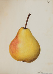
After his trip west Sprague returned briefly to the South Shore, working as a clerk in a Nantasket Beach hotel until, the following year, he started to work as an illustrator for prominent American botanist Asa Gray, first producing illustrations for his 1845 Lowell lectures at Harvard.  Before long he moved to Cambridge, continuing to work for Gray and other Harvard professors, illustrating several comprehensive botanical volumes in the 1840s and 1850s.  (The illustration to the left, of Aesculus Parviflora, is from an 1848 work, Trees and Shrubs of New England.)

Hingham’s Unbuilt Highways, Part 2

As discussed in our prior post, Hingham’s Unbuilt Highways, Part 1, traffic has been an issue for the Town of Hingham for nearly 100 years.  This has been particularly true for Main Street.  Each time the State proposed a plan to solve the problem, though, concerned citizens have stepped forward to oppose what they saw as a threat to the town’s character.

When Route 128 was extended into Hingham (heading to Nantasket Beach) in the late 1920s,  increased complaints about traffic on Main and East Streets led the State, by the mid-1930’s, to promise a bypass route for traffic relief.  The route that it proposed followed Gardner Street, starting at Whiting Street, crossing Main Street, and eventually turning north through the less developed eastern part of town into Hull. Funding issues stalled any actual construction, however. In 1938, the State offered a “temporary fix,” offering to build a rotary in Hingham Centre at the intersection of Main, Short, and Middle Streets.

The Hinghamite, August 1941

August 1941 issue of The Hinghamite, a monthly newspaper published by Albert L. Pitcher during the 1940s

As reported in August 1941 issue of The Hinghamite, the rotary plan, which probably would have resulted in several historic buildings being torn down, was halted by the efforts of Mrs. David T. Whiton and Miss Ethel H. Studley, owners of some of potentially effected properties.  They gathered a petition of nearly 250 names and packed a public hearing which convinced the State to back down. The Town did agree to better signage, more traffic islands, and other measures to help ease traffic problems.

View of Hingham Centre from corner of Main and Short Streets, 9/8/13

Hingham Centre, as seen from the corner of Main and Short Streets in September 2013. Some of these buildings might have been torn down if the State’s rotary proposal had gone forward. Photo by Robert H. Malme

By the 1950’s and the dawn of America’s freeway age, renewed efforts were made to take traffic off Main Street, this time with a proposed relocated Route 128 expressway. Highway surveyors were for time a constant presence in several parts of town.  Leavitt Street resident Carl Burr (whose diary we have blogged about previously) mentioned being visited due to his property being in the potential path of the new highway. By the time the State got serious about the project in the late 1960s, the southern end of Route 128 had been pushed back to Braintree, and the route running through Hingham to Hull was renumbered Rote 228. On February 29, 1968 the State held a public hearing at Hingham High School to describe its proposal for a relocated Route 228:

Proposed Relocation of Route 228 in Hingham-Norwell-Hull

The State’s proposal was an 8-mile, four-lane expressway (250 to 400 feet wide) from Route 3 to George Washington Blvd. in Hull.  According to the State, this would fulfill three specific goals: to stimulate residential development and recreational activities for the towns along its route, to provide traffic relief to local streets, and to provide safety, comfort and reduced travel times to motorists. The State offered three alternatives for this proposed expressway’s route through the southern and middle parts of Hingham.

Proposed Relocation of Route 228 in Hingham, Norwell and Hull

The “Gardner Line” alternative began at an interchange with Route 3 in vicinity of today’s Derby Street Shoppes, taking the route across Whiting Street and south of Gardner Street, across Main Street then turning north in the vicinity of Prospect Street. The two other alternatives, the “Pond Line” and the “Webster Line” started at Route 3 in Norwell and ran north to Prospect Street.  From Prospect Street, all three proposed routes proceeded north along a “Common Line” running parallel to the border of today’s Wompatuck State Park.  North of Free Street (where an interchange was planned), three alternative routes were again proposed north to Hull.  Two of these proposed routes, the “Western” and “West Central” Lines would have required “relocating” Triphammer Pond and the Weir River.  The “Eastern Line” would have run east of Triphammer Pond but would have skirted Turkey Hill.

All three proposed routes intersected with Route 3A (with a large interchange) at between Summer Street and today’s Weir River Farm. Any of the alternatives would have condemned 17 to 26 houses and requiring those living in them to move and would have cost $12 to $15 million (in 1968 dollars).

View from Top of Turkey Hill

View from top of Turkey Hill–which would have been much different if the Route 228 expressway had been built.  Photo by Robert H. Malme, May 2015

Many Town officials were receptive to the plan, provided that the State chose one of the Norwell routes. The Selectmen even asked the State to add an interchange at Rockland Street in the event the Eastern Line was chosen. In the spring of 1968, however, Norwell rejected the proposed routes within its borders due to their proximity to the municipal water supply, and the State indicated that the Gardner Line would probably be its recommended southern alternative.

At a Special Town Meeting held on September 30, 1968, Hingham voters rejected the State’s plans by a narrow vote of 559-506.  (A second article, requiring the Selectmen to insist upon the Pond-Common-Eastern Line configuration if the State moved forward with a highway despite the Town’s vote, passed 422-231). Since neither Norwell nor Hingham would approve a southern route through their respective towns, no construction was started. By the early 1970s, with continued opposition and with overall sentiment for expressway-building waning in the metro Boston area waning (a trend exemplified by the cancellation of the Southwest Expressway in Boston), the State abandoned the plan.

Continued traffic problems on Main Street, however, revived the idea of building a relocated Route 228 in the early 1990s. Several frustrated Main Streets resident asked Selectmen to reconsider the State’s 1960s plan. This time, however, a large majority of town citizens and the town’s officials stood up against this idea. Their sentiments were best summed up in a letter which John P. Richardson wrote to the editor of the Hingham Mariner on August 8, 1993, arguing that any such highway would ruin one of the town’s gems, Wompatuck State Park.

richardsonletter8893

Letter to the Editor of the Hingham Mariner, written by John P Richardson on August 8, 1993.

The idea died quietly and has not been revived. Current sentiment with building new roads to solve traffic problems can best be summed up by the response of the Town Traffic Committee to the complaint of a frustrated Main Street resident, as reported in the July 29, 1993 Hingham Mariner.  When the Main Streeter asked what could be done for relief from the traffic noise, the response was, “Move to Plymouth.”

Hingham R.F.D.

Ervin Horton in his Stanley Steamer (1911)
This 1911 shot from our photo archives depicts Ervin Horton (1876-1959), at the time a Hingham mail carrier, in his Stanley Steamer automobile. When we reproduced the photo in Michael Shilhan’s 1976 local history, When I Think of Hingham, the caption read, “Ervin S. Horton and his red Stanley Steamer on South Street in front of the Post Office, July 31, 1911.”

Ervin’s son, Howard Leavitt Horton (1904-1983), memorialized the Hingham of his youth in letters, stories, water color paintings, and sound recordings, many of which are in our archives. Here, in a 1975 letter written to Historical Society President James W. Wheaton, an elderly Howard Horton remembers his father, the delivery route, and the car:

I remember driving around the Hingham R.F.D. mail route with my father in that old Stanley Steamer . . . . We started up Fearing Road and turned right past the old Cadet Field (now Derby) and then left at the foot of the hill by the harbor and over Otis Street then turned right on Downer Avenue passing the Crow Point Inn and to the Steamboat Landing. Then we took a very sharp left turn and up a very steep hill, Steamboat Lane. This was before 1915 and there were few automobiles in Hingham then and I doubt if any of them except my father’s Stanley Steamer could go up that hill after a sharp turn. The old Stanley Steamer just went up that hill puffing steam with no trouble at all. The Crow Point Golf Club was at the top of the hill and then we turned right and there was a beautiful view of Boston Harbour. . . .

In those days there was an old blacksmith shop as we turned right leaving Downer Avenue on Lincoln Street . . . Mr. Wing’s blacksmith shop and then Jerry Breen’s farm house and barn with a windmill which pumped water from a well for use on his truck garden. There were several of these farms in Hingham and they all drove over Lincoln Street early in the dawn to get to the market district on Hanover and Blackstone streets at Boston by daylight, these huge wagons requiring two horses and sometimes four. . . .

Crow Point Golf Club
This postcard dates from 1915, around the time young Howard Horton accompanied his father on summertime mail delivery trips up the hill to the Crow Point Golf Club, a 9-hole golf course located at the top of Paige Hill, off Howe Street.
Steamboat Hill

Steamboat Hill ran up from the former steamboat landing–where the Hingham  Yacht Club now has its pier:  the sharp left up the hill remains in place today.  The painting above, showing Steamboat Hill from the far side, was made somewhat earlier, in 1895–the year before Melville Garden was closed and development of Crow Point accelerated.

Hingham’s Unbuilt Highways, Part 1

For nearly the last 100 years, residents of Hingham have had to deal with traffic congestion in its downtown, the harbor area, and along Main Street. The recent effort by the town to survey residents about possible improvements to Route 3A and Summer Street is only the latest attempt to try to solve the town’s traffic problems. Documents from the John Richardson Collection and other materials in our archives confirm that the search for a solution to traffic problems has a long history.

Starting in the 1920’s the town asked the state to fund a project to take beach and through traffic away from Hingham Square. The state took the easiest solution and expanded Broad Cove Road and Otis Street to four lanes so that 3A could be re-routed away from the eastern end of Lincoln Street and North Street in 1932. Though successful, this action reduced the ability for non-automobile traffic to easily access the waterfront from that date forward. Around the same time, to further speed Nantasket and other traffic east of the Harbor, the state also built Chief Justice Cushing Highway, with the now infamous Harbor Rotary, and constructed George Washington Blvd. to Hull.

Looking North towards the Harbor Rotary in 1941:

Hingham Rotary and Harbor (1941)With the 1950s came the start of the freeway era in the country and Massachusetts. By 1959, the state had completed the 128 Beltway, the Central Artery, and the Southeast Expressway as far as Derby Street (later to be Route 3). Hingham officials saw the new expressway as an opportunity to attract tax-producing industrial and commercial development to South Hingham but also worried about what a potential residential population boom would do to the town. With these thoughts in mind, the Hingham Planning Board produced a report called the ‘1959 Town Plan Summary’ which projected Hingham’s population as 25,000 by 1980 and made a series of recommendations to best accommodate this growth while preserving the town’s character.

Cover of 1959 Planning Board Report:

1959 Hingham Town Plan Summary

The report made two recommendations to help increase recreational use of the Harbor. The first was to fill parts of it to connect the Harbor islands to the mainland and build a marina where the Yacht Club is now, as seen in the map below.

Hingham Harbor Plan (1959)

Second to ease waterfront access to town citizens, and to help solve many of the town’s traffic problems, the Board recommended building a pair of parkways (which, depending on costs, would be built as limited access expressways right away, or upgraded to them in the future) to take Nantasket and other through traffic away from the Harbor area and from Main Street (see Location A in the map below). The north-south parkway would take through traffic from Route 3A at the Back River Bridge southward parallel to Beal Street (by the Ammunition Depot, slated to close and holding out the opportunity for industrial development) and then further south along the western side of town to Route 3. The east-west parkway would then take southbound and Nantasket traffic east, following a route through the center of Town, north of High and Free Streets, and then across 3A to George Washington Blvd.

1959 Hingham Highway Plan

Neither of these plans got off the drawing board: they appear to have largely been an alternative to the state’s known plans for the Hingham area, which included, as can be seen referenced on the top left side map, the Shawmut Trail. The Shawmut Trail was a proposed expressway that would have run from Route 3 near today’s Braintree Split eastward across the Fore River (over a new bridge) to Route 3A in Weymouth just west of the Back River Bridge. It would then have continued into Hingham mostly along the path of Route 3A to end at the proposed Route 128 (later 228) Expressway near Turkey Hill (shown on Map C). As can be seen on the Location B and C Maps above, a portion of the Shawmut Trail route would have run directly from the Broad Cove Rd/Otis Street intersection to the Rotary. This would, as the report notes, involve running Route 3A “on a dike across the southern shallows of the Harbor cutting off the ponded areas from further recreational or boating use.” In other words, this plan would have prevented most of the current activities in the southern end of the harbor.

View of the southern end of Hingham Harbor from the Bathing Beach in 2014, a scene that would not be possible if the Shawmut Trail had been built:

View of the southern end of Hingham Harbor from Bathing Beach, 8/9/14
Photo by Robert H. Malme, 8/9/14

Needless to say, this plan did not impress Hingham’s citizens or town officials. By the end of 1968 the state relented and ended the proposed Shawmut Trail in Weymouth. In the early 1970s the state officially abandoned the plan. Though none of these proposal came to be, a plan to build a relocated 228 expressway came much closer to fruition. More about that in Part 2.


Hingham Artists to Know: Franklin Whiting Rogers (Part II)

(Part II of a blog post on Hingham artist Franklin Whiting Rogers. Part I can be found here.)

Rogers was born in 1854 in Cambridge, the middle son of three boys born to Edward Coit Rogers, a widower, and his second wife, Elizabeth Lothrop Seymour, daughter of Joel and Polly (Whiton) Seymour of Hingham. Edward and Elizabeth were both educated, intellectual, active in social reform and the abolitionist movement, authors and members of the Universalist Society.

Franklin Whiting Rogers

Photograph of Franklin Whiting Rogers. Courtesy of David and Shirley Rogers of Hingham, Mass.

In 1856, Edward suffered failing health so Elizabeth brought her young sons and their half-brothers back to Hingham to live with her family. Edward died in 1860 and young Franklin was raised in Hingham until age 16, when he moved to Boston to attend art school.
He later entered the studio of J. Foxcroft Cole, a fine painter in the French Barbizon style then fashionable: nostalgic rural landscapes often in misty light. A talented student, Rogers advanced rapidly with his master. European training was considered essential to further a painter’s career so Cole turned his promising student over to artist Thomas Robinson of Boston who studied in Paris and excelled in painting of animals and landscapes, which later became Rogers’ specialties.

Robinson made frequent buying trips to Europe for prominent New England art dealers, as did fellow Boston artist William Morris Hunt, who helped introduce the Barbizon painters to the avid Boston art market. Robinson also promoted local artists and it was through his studio that young Rogers met Hunt, then at the height of his career. Hunt, a respected teacher, became a lasting influence on Rogers’ career as an inspiration and mentor: his guide-book for artists taught “a way of seeing that stressed emotional carrying power and individual feeling expressed in a painterly style.” Hunt’s work was influenced by the technical bravura of French artist Thomas Couture and the spiritual fervor of Jean-Francois Millet.

Rogers exhibited often and widely and in 1884 returned to Hingham with an established reputation and following for both his animal and landscape subjects. Working from a studio on High Street, he expanded his circle of artist mentors and friends and became acquainted with Winckworth Allan Gay and Alexander Pope, noted local artists. In 1886, Rogers moved his studio to 33 Free Street where he bought a home; he worked there until the end of his life in 1917. The studio no longer exists but his house has remained in the family where his grandson, David, and wife, Shirley, live today.

Rogers painted “alla prima,” a more straightforward broad application of paint compared to the classical technique of building a painting with a series of transparent glazes over a monochrome underpainting. Strictly defined, an “alla prima” painting would be started and finished in one session but the term is also more loosely applied to any painting done in a direct and expressive style that promotes painterly freshness of response to the subject.

But Sisters, or Four Hounds (reproduced below) was not painted in one afternoon! Capturing the poetic informality of the pile of sleeping dogs on a dusty blanket, required a great deal of preparation—followed by revisions, over-painting and even some glazes for the finishing touch.

Sisters, or Four Hounds

Sisters, or Four Hounds by Franklin Whiting Rogers

Rogers would begin by creating charcoal or pencil studies of group-ings as well as studies of each animal to get acquainted with their personality and body. A series of small “thumbnails” would be created next as he experimented with the group composition – finally settling on a classic pyramid grouping that leads your eye in a circle of nodding heads. Next, value studies would help establish his patterns of light and dark born known as “chiascuro,” that serves to model the dogs’ bodies and organize the interior space.
When ready to paint, the artist likely prepared the stretched canvas by toning it with a middle-value wash, perhaps of an umber. (This enables a painter to better assess his colors when not seen against a white canvas.)
His next step would be to create “a map,” lightly drawn marks to indicate the shapes in his composition—or he may have massed in shadow shapes with thin paint and used a rag to pull out paint for areas of light. When satisfied with this preparation, Rogers mixed oil colors on his palette and applied them according to the rule of thumb “lean over fat,” which means initial paint strokes would be executed with paint thinned a bit with turpentine with the thickest application of paint, “impasto,” saved for areas in light painted last.
There might have been multiple sittings with the animals throughout the process of painting to ensure he expressed each dog’s individual character. “Eye candy” would be those last accents that enliven the work and lend an individual truth and charm: the highlights on a dog’s brow and paws, the texture of fur, the fuzz on the blanket. The painting process probably took several weeks before Rogers was satisfied that he had captured the spirit of his sitters and resolved the formal painterly issues that helped create a masterpiece