Hingham’s Unbuilt Highways, Part 1

For nearly the last 100 years, residents of Hingham have had to deal with traffic congestion in its downtown, the harbor area, and along Main Street. The recent effort by the town to survey residents about possible improvements to Route 3A and Summer Street is only the latest attempt to try to solve the town’s traffic problems. Documents from the John Richardson Collection and other materials in our archives confirm that the search for a solution to traffic problems has a long history.

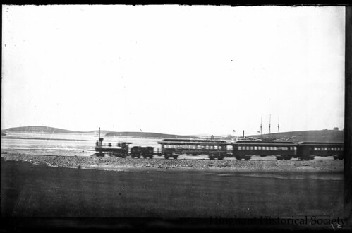
Starting in the 1920’s the town asked the state to fund a project to take beach and through traffic away from Hingham Square. The state took the easiest solution and expanded Broad Cove Road and Otis Street to four lanes so that 3A could be re-routed away from the eastern end of Lincoln Street and North Street in 1932. Though successful, this action reduced the ability for non-automobile traffic to easily access the waterfront from that date forward. Around the same time, to further speed Nantasket and other traffic east of the Harbor, the state also built Chief Justice Cushing Highway, with the now infamous Harbor Rotary, and constructed George Washington Blvd. to Hull.

Looking North towards the Harbor Rotary in 1941:

Hingham Rotary and Harbor (1941)With the 1950s came the start of the freeway era in the country and Massachusetts. By 1959, the state had completed the 128 Beltway, the Central Artery, and the Southeast Expressway as far as Derby Street (later to be Route 3). Hingham officials saw the new expressway as an opportunity to attract tax-producing industrial and commercial development to South Hingham but also worried about what a potential residential population boom would do to the town. With these thoughts in mind, the Hingham Planning Board produced a report called the ‘1959 Town Plan Summary’ which projected Hingham’s population as 25,000 by 1980 and made a series of recommendations to best accommodate this growth while preserving the town’s character.

Cover of 1959 Planning Board Report:

1959 Hingham Town Plan Summary

The report made two recommendations to help increase recreational use of the Harbor. The first was to fill parts of it to connect the Harbor islands to the mainland and build a marina where the Yacht Club is now, as seen in the map below.

Hingham Harbor Plan (1959)

Second to ease waterfront access to town citizens, and to help solve many of the town’s traffic problems, the Board recommended building a pair of parkways (which, depending on costs, would be built as limited access expressways right away, or upgraded to them in the future) to take Nantasket and other through traffic away from the Harbor area and from Main Street (see Location A in the map below). The north-south parkway would take through traffic from Route 3A at the Back River Bridge southward parallel to Beal Street (by the Ammunition Depot, slated to close and holding out the opportunity for industrial development) and then further south along the western side of town to Route 3. The east-west parkway would then take southbound and Nantasket traffic east, following a route through the center of Town, north of High and Free Streets, and then across 3A to George Washington Blvd.

1959 Hingham Highway Plan

Neither of these plans got off the drawing board: they appear to have largely been an alternative to the state’s known plans for the Hingham area, which included, as can be seen referenced on the top left side map, the Shawmut Trail. The Shawmut Trail was a proposed expressway that would have run from Route 3 near today’s Braintree Split eastward across the Fore River (over a new bridge) to Route 3A in Weymouth just west of the Back River Bridge. It would then have continued into Hingham mostly along the path of Route 3A to end at the proposed Route 128 (later 228) Expressway near Turkey Hill (shown on Map C). As can be seen on the Location B and C Maps above, a portion of the Shawmut Trail route would have run directly from the Broad Cove Rd/Otis Street intersection to the Rotary. This would, as the report notes, involve running Route 3A “on a dike across the southern shallows of the Harbor cutting off the ponded areas from further recreational or boating use.” In other words, this plan would have prevented most of the current activities in the southern end of the harbor.

View of the southern end of Hingham Harbor from the Bathing Beach in 2014, a scene that would not be possible if the Shawmut Trail had been built:

View of the southern end of Hingham Harbor from Bathing Beach, 8/9/14
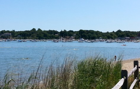
Photo by Robert H. Malme, 8/9/14

Needless to say, this plan did not impress Hingham’s citizens or town officials. By the end of 1968 the state relented and ended the proposed Shawmut Trail in Weymouth. In the early 1970s the state officially abandoned the plan. Though none of these proposal came to be, a plan to build a relocated 228 expressway came much closer to fruition. More about that in Part 2.


Carl Burr’s Hingham, Part 1

Thanks to the generosity of Hingham resident Gerry Bennett, the Historical Society has recently been loaned the diaries of Carl Burr (1884-1961), a seventh generation Hingham resident who lived his entire life at the family homestead at 61 Leavitt Street, across from today’s Hingham Public Library. I have just completed cataloging these diaries to make them accessible to researchers and others interested in this local history resource. Click on the link to read the full Carl Burr Diaries Finding Aid.

Photo of the Burr Homestead on Leavitt Street in 1885 and beyond. Taken by Charles Marble from the roof of Agricultural Hall:

Burr Homestead in 1885

Carl Burr was the eleventh child of Elisha Burr (1839-1909) and Mary Pratt Burr (1842-1940). He married Esther (Essie) M. Snyder (1889-1975) of Cohasset on June 15, 1910 and they raised two children, Alston P. Burr (1910-1979), who after 1940 lived next door at 67 Leavitt Street, and Constance (Connie) Burr Talbot (1915-1989) who spent her married life in Darien, Connecticut. He kept a daily diary for most of his adult life. The entries provide a window on a Hingham that was changing rapidly from a rural farm town in the early 1900s to the suburban community it is today. Changes that are evident through his diary’s descriptions of modes of transportation and use of open space.

Transportation
Carl Burr never owned a car. He didn’t have to travel far to visit family. Carl’s younger brother, noted decoy maker Russ Burr (1887-1955), lived next door at 55 Leavitt Street until his death in 1955, older sister Mary (May) Burr Ripley (b. 1878) and her husband William (Bill) Ripley (b. 1876) lived two doors up at the corner of Leavitt and Spring Streets.

Burr Homestead houses along 57, 61 and 67 Leavitt Street, 5/2/15

Burr Homestead houses along 57, 61 and 67 Leavitt Street. Photo taken May 2, 2015 by Robert H. Malme.

He was within walking distance of stores in both Hingham Center and Hingham Square. In his early years he was a plumbing and heating contractor and his entries list his extensive use of the local street railway system to visit clients throughout Hingham and neighboring communities.

Hingham Street Railway Car on Main Street near Pear Tree Hill:
Hingham Street Railway Company Car, Pear Tree Hill

He used the Nantasket and Old Colony railroad lines to take off-hour excursions to Nantasket Beach and Paragon Park or to travel to Cohasset to visit his future wife.

Nantasket Beach Railroad Train c. 1900 Nantasket Railway train heading towards Hingham near the Weir River around 1900, courtesy of the Hingham Historical Society.

Through connecting rail lines in other towns, he could travel far from home. He writes on August 15, 1909 traveling to Providence, RI via ‘the electrics’ for a dinner. In the 1920’s he became maintenance supervisor to buildings in Boston and started daily commutes via the Old Colony Railroad into South Station often returning home in the early afternoon. And like this past winter season, he noted several times when severe snowstorms prevented the trains from running.

Passengers board Old Colony Railroad train at Hingham Square Depot around 1930:

Hingham Square Train Station

As the years went on, particularly after World War II, however, the railroad started to give way to the popularity of the automobile. His entries refer to rail service starting to get cut back. On April 3, 1948 he notes he can no longer take a 12:30PM trip back to Hingham from Boston, but must now take a train to Quincy and then a bus. By the late 1940s, any late evening work would require his son Allston picking him up in his car from Quincy or the ‘rapid transit’ station at Columbia, today’s JFK-UMass station. After he stopped working in Boston in 1951, he started to rely totally on family, or friends, to transport him around town or elsewhere. Toward the end of his life, on September 8, 1959 he noted traveling on the new Southeast Expressway, its opening causing the end of railroad service in Hingham for nearly 50 years.

Hingham Square Train Depot being demolished in 1949:
Demolition of Hingham Square Train Station

Part two will discuss the changes the diaries chronicle in Hingham’s open spaces.

Enjoying the “Cool Sea Breezes” at Hingham’s Old Colony House

The advent of mass transportation in the mid-19th century helped create the summer tourism industry that has been so important to our regional economy.  When New England and the Sea, an historical survey of our maritime heritage, addresses the rise of seaside resorts, it tips its hat to Hingham:  “. . . one had to have a summer house at the shore, or go to the White Mountains, or stay at one of the fashionable hotels—say, the Old Colony House at the head of the harbor in Hingham . . . .”

A gathering in front of the Old Colony House. Photograph from the archives at the Hingham Historical Society.

Built in 1832 by the Boston & Hingham Steamship Company, the Old Colony House was an early example of the symbiotic relationship between the infant transportation and recreation industries.  The steamboat General Lincoln made the trip from Boston to Hingham swift (around 75 minutes) and pleasant, while the Old Colony House, erected on Summer Street near Martin’s Lane, created a destination, increasing passenger traffic on the vessel.  The railroad came through Hingham in 1849, and one of the stops on the new South Shore Railroad, called “Old Colony House,” was close by the hotel, providing easy access from Boston—and soon thereafter, the opportunity to change trains for Nantasket.  (The station’s descendent is today’s Nantasket Junction stop on the MBTA Greenbush Line.)  After the Civil War, the great Nantasket hotels drew business away from the Old Colony House, which was in decline when it burned in 1872.

The Historical Society’s archives include a collection of the business papers of Alfred C. Hersey.  Among Hersey’s many business interests (largely in the shipping and transportation industries) was the Old Colony House, which the steamship company sold in the late 1830’s.  Hersey’s 21-page handwritten inventory of the hotel’s furnishings, made in May 1860, provides important detail about what a New England resort hotel of the 1860’s was really like.

The inventory faithfully describes the furnishings of each room of the hotel, including dining room, parlors, billiard room, bowling alley, and office, specifying quantities, materials, and state of repair.  In the “East Parlor,” for instance, guests could sit on their choice of 6 damask covered sofas (4 “slightly stained”), 1 stuffed arm chair, 13 black walnut stuff bottom chairs, a stuffed rocking chair, and 10 black arm chairs (which had among them, however, only 8 cushions).

A typical guest room was furnished with a bedstead, mattresses, bolster and pillow, bureau, washstand, looking glass, mosquito netting, chamber pot and cover, soap cup, mug, and curtains.  A servant’s room in the attic, by contrast, had a bedstead, mattress, bolster and pillow (“stained”), wooden chair, toilet table (“defaced”), “small” looking glass, basin and ewer, and soap cup.  (Servants’ rooms in the scullery appear to have had significantly fewer furnishings.)

The inventories of the kitchen and laundry provide detailed lists of equipment.  To launder the hotel linens and guests’ clothes required water casks, grease casks, basins, wash boards, starch pans, a mangle, clothes horses, brushes, 11 flat irons, iron racks, and an iron heater.

The contents of the kitchen and “pastry room” tell us about the hotel’s fare.  There were large and small frying pans, copper and iron sauce pans, a meat saw, large and small steamers, tin and copper baking and cake pans, iron cake molds, tin jelly molds, a gridiron, waffle irons, coffee pots, a tea chest, ice cream freezers, an ice cream chest, and an ice cream scoop.  The “pastry room” was furnished with a bed—the pastry cook must have needed to rise early.

In a series of travel letters published as A Trip to Boston in 1838, Enoch Cobb Wines wrote warmly of the

splendid and well-kept Old Colony Hotel, the refined social pleasures it affords, the noble view enjoyed from the observatory on its roof, and the cool sea breezes that almost enable you to put summer at defiance. . . . [It]t presented a gay and happy appearance.  The broad piazza which surrounds three sides of the house was thronged with smiling groups, in which a due intermixture of the gentler sex was not wanting . . . .

. . . There was an excellent band from Boston there, and we had the poetry of music, the poetry of motion, and the poetry of social happiness, all in high perfection; and afterwards the poetry of sound sleep in the cool air, for which the proprietor of the Old Colony seems to have made a perpetual contract.